IOOS Glider DAC
The mission of the IOOS Glider DAC (GDAC) is to provide glider operators with a simple process for submitting glider data to a centralized location. This enables the data to be visualized, analyzed, widely distributed via existing web services and the Global Telecommunications System (GTS) and archived at the National Centers for Environmental Information (NCEI).
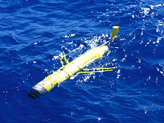
As scientists deploy more gliders, they are revolutionizing how we observe our ocean. These robots profile the water column, collecting information that creates a more complete picture of the ocean, especially below the surface, at lower cost and less risk than ever before.
The IOOS GDAC and the associated GDAC Map feature current and historical glider missions dating back to 2005. The GDAC includes data from all IOOS Regional Associations (RAs), with significant contributions from the NOAA Atlantic Oceanographic and Meteorological Laboratory (AOML) and other partners across the federal and academic sectors, including NOAA, the U.S. Navy, NSF, and various universities.
